Quick contacts
-
924/1 Cummerata Mission, Los Angeles, USA, Inc - 4852
-
Monday: 13:00-18:00


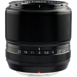
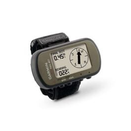
60mm (35mm Equivalent Focal Length: 91mm)
f/2.4
f/22
FUJIFILM X
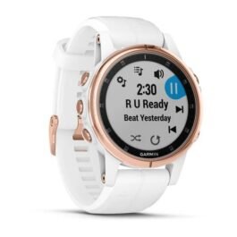
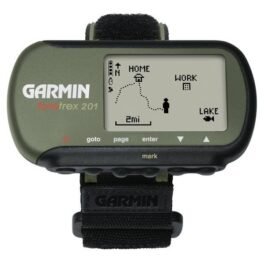
| Age Range | Adult |
|---|---|
| Batteries Included | Yes |
| Brand | Garmin |
| Color | White |
| Display Size | 1.1 Inches |
| Display Type | Analog-Digital |
| Included Components | Garmin Fenix 5S Multisport Watch, 42 mm (White with Carrara White Band) |
| Shape | As shown in the image |
| Map Type | Satellite |
| Material Type | As shown in the image |
| Number of Items | 1 |
| Size | 42 mm |
| Features | Multisport GPS watch |
| Sport | Hiking |
| Style | Regular Glass |
| Manufacturer | Garmin Corporation |
General |
|
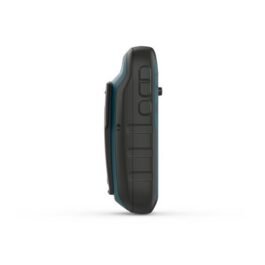
| Physical dimensions | 2.9″ x 1.7″ x 0.9″ |
| Weight | 3.1 oz with batteries |
| Water rating | IPX7 |
| Battery | 2 AAA batteries (not included) |
| Display type | black and white LCD |
| Display size | 1.6″ |
| Display resolution | 100 x 64 pixels |
| Battery life | Up to 17 hours in GPS mode |
| Interface | USB |
Maps & Memory |
|
| Basemap | |
| Waypoints/favorites/locations | 500 |
| Routes | 20 |
| Track log | 10,000 |
Sensors |
|
| Barometric altimeter | |
| Compass | |
Outdoor Recreation Features |
|
| Area calculation | |
| Hunt/fish calendar | |
| Sun and moon information | |
Additional |
|
| Additional |
|
General |
|
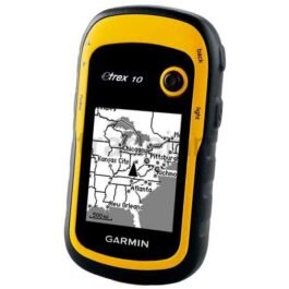
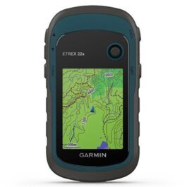
| Physical dimensions | 7.3 x 4.3 x 2.2 cm |
| Weight | 87.8 g with batteries |
| Water rating | IPX7 |
| Battery | 2 AAA batteries (not included) |
| Display type | High-resolution 4-colour grey |
| Display size | 2.0″ diagonal |
| Display resolution | 200 x 128 pixels |
| Battery life | Exceeds 48 hours in GPS mode; up to 1 week in UltraTrac™ mode; up to 1 month in watch mode |
| Interface | USB |
Maps & Memory |
|
| Basemap | |
| Waypoints/favorites/locations | 500 |
| Routes | 20 |
| Track log | 10,000 |
Sensors |
|
| Barometric altimeter | |
| Compass | |
Outdoor Recreation Features |
|
| Area calculation | |
| Hunt/fish calendar | |
| Sun and moon information | |
Garmin Connect™ |
|
| Garmin Connect™ compatible (online community where you analyse, categorise and share data) | |
Additional |
|
| Additional |
|
General |
|
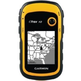
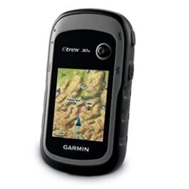
| Physical dimensions | 7.3 x 4.3 x 2.2 cm |
| Weight | 87.8 g with batteries |
| Water rating | IPX7 |
| Battery | 2 AAA batteries (not included) |
| Display type | High-resolution 4-colour grey |
| Display size | 2.0″ diagonal |
| Display resolution | 200 x 128 pixels |
| Battery life | Exceeds 48 hours in GPS mode; up to 1 week in UltraTrac™ mode; up to 1 month in watch mode |
| Interface | USB |
Maps & Memory |
|
| Basemap | |
| Waypoints/favorites/locations | 500 |
| Routes | 20 |
| Track log | 10,000 |
Sensors |
|
| Barometric altimeter | |
| Compass | |
Outdoor Recreation Features |
|
| Area calculation | |
| Hunt/fish calendar | |
| Sun and moon information | |
Garmin Connect™ |
|
| Garmin Connect™ compatible (online community where you analyse, categorise and share data) | |
Additional |
|
| Additional |
|
General |
|
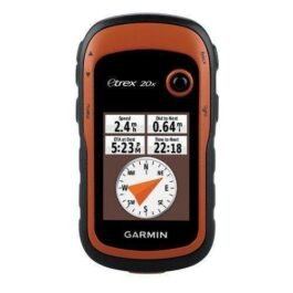
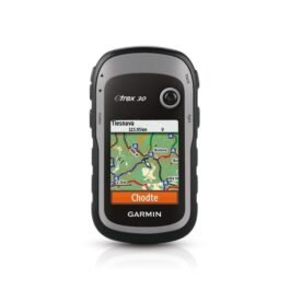
| PHYSICAL DIMENSIONS | 2.1″ x 4.0″ x 1.3″ (5.4 x 10.3 x 3.3 cm) |
|---|---|
| DISPLAY SIZE | 1.4″ x 1.7″ (3.6 x 4.3 cm); 2.2″ diag (5.6 cm) |
| DISPLAY RESOLUTION | 128 x 160 pixels |
| DISPLAY TYPE | transflective, monochrome |
| WEIGHT | 5 oz (141.7 g) with batteries |
| BATTERY TYPE | 2 AA batteries (not included); NiMH or Lithium recommended |
| BATTERY LIFE | 25 hours |
| WATER RATING | IPX7 |
| HIGH-SENSITIVITY RECEIVER | |
| INTERFACE | mini USB |
| MEMORY/HISTORY | 6 MB |
Maps & Memory |
|
| BASEMAP | |
|---|---|
| WAYPOINTS/FAVORITES/LOCATIONS | 1000 |
| TRACKS | 100 |
| TRACK LOG | 10000 points, 100 saved tracks |
| ROUTES | 50 |
Sensors |
|
| GPS | |
|---|---|
| GLONASS | |
| GPS COMPASS (WHILE MOVING) | |
Outdoor Recreation |
|
| POINT-TO-POINT NAVIGATION | |
|---|---|
| COMPATIBLE WITH BASECAMP™ | |
| AREA CALCULATION | |
| HUNT/FISH CALENDAR | |
| SUN AND MOON INFORMATION | |
| GEOCACHING-FRIENDLY | Yes (Paperless) |
Physical & Performance: |
|
| Physical dimensions | 2.1″ x 4.0″ x 1.3″ (5.4 x 10.3 x 3.3 cm) |
| Display size, WxH | 1.4″ x 1.7″ (3.5 x 4.4 cm); 2.2″ diag (5.6 cm) |
| Display resolution, WxH | 240 x 320 pixels |
| Display type | 2.2″ transflective, 65K color TFT |
| Weight | 5 oz (141.7 g) with batteries |
| Battery | 2 AA batteries (not included); NiMH or Lithium recommended |
| Battery life | 25 hours |
| Water rating | IPX7 |
| High-sensitivity receiver | |
| Interface | USB |
Maps & Memory: |
|
| Basemap | |
| Ability to add maps | |
| Built-in memory | 3.7 GB |
| Accepts data cards | microSD™ card (not included) |
| Custom POIs (ability to add additional points of interest) | |
| Waypoints/favorites/locations | 2000 |
| Routes | 200 |
| Track log | 10,000 points, 200 saved tracks |
Outdoor Features: |
|
| Automatic routing (turn by turn routing on roads) | (with optional mapping for detailed roads) |
| Geocaching-friendly | (paperless) |
| Custom maps compatible | |
| Sun and moon information: | |
| Tide tables | (with optional Bluechart) |
| Area calculation | |
| Picture viewer | |
Garmin Connect™ |
|
| Garmin Connect™ compatible (online community where you analyze, categorize and share data) | |
General |
|
| PHYSICAL DIMENSIONS | 2.1″ x 4.0″ x 1.3″ (5.4 x 10.3 x 3.3 cm) |
|---|---|
| DISPLAY SIZE | 1.4″ x 1.7″ (3.5 x 4.4 cm); 2.2″ diag (5.6 cm) |
| DISPLAY RESOLUTION | 240 x 320 pixels |
| DISPLAY TYPE | 2.2″ transflective, 65K color TFT |
| WEIGHT | 5 oz (141.7 g) with batteries |
| BATTERY TYPE | 2 AA batteries (not included); NiMH or Lithium recommended |
| BATTERY LIFE | 25 hours |
| WATER RATING | IPX7 |
| HIGH-SENSITIVITY RECEIVER | |
| INTERFACE | mini USB |
| MEMORY/HISTORY | 8 GB |
Maps & Memory |
|
| PRELOADED MAPS | yes (TopoActive; routable) |
|---|---|
| ABILITY TO ADD MAPS | |
| BASEMAP | |
| AUTOMATIC ROUTING (TURN BY TURN ROUTING ON ROADS) FOR OUTDOOR ACTIVITIES | |
| MAP SEGMENTS | 3000 |
| BIRDSEYE | 250 BirdsEye Imagery files |
| INCLUDES DETAILED HYDROGRAPHIC FEATURES (COASTLINES, LAKE/RIVER SHORELINES, WETLANDS AND PERENNIAL AND SEASONAL STREAMS) | |
| INCLUDES SEARCHABLE POINTS OF INTERESTS (PARKS, CAMPGROUNDS, SCENIC LOOKOUTS AND PICNIC SITES) | |
| DISPLAYS NATIONAL, STATE AND LOCAL PARKS, FORESTS, AND WILDERNESS AREAS | |
| EXTERNAL MEMORY STORAGE | yes (32 GB max microSD™ card) |
| WAYPOINTS/FAVORITES/LOCATIONS | 2000 |
| TRACKS | 200 |
| TRACK LOG | 10000 points, 200 saved tracks |
| ROUTES | 200 routes, 250 points per route; 50 points auto routing |
Sensors |
|
| GPS | |
|---|---|
| GLONASS | |
| GPS COMPASS (WHILE MOVING) | |
Outdoor Recreation |
|
| POINT-TO-POINT NAVIGATION | |
|---|---|
| COMPATIBLE WITH BASECAMP™ | |
| AREA CALCULATION | |
| HUNT/FISH CALENDAR | |
| SUN AND MOON INFORMATION | |
| GEOCACHING-FRIENDLY | Yes (Paperless) |
| CUSTOM MAPS COMPATIBLE | yes (100 custom map tiles) |
| PICTURE VIEWER | |
Physical & Performance |
|
| Physical dimensions | 2.1″ x 4.0″ x 1.3″ (5.4 x 10.3 x 3.3 cm) |
| Display size, WxH | 1.4″ x 1.7″ (3.5 x 4.4 cm); 2.2″ diag (5.6 cm) |
| Display resolution, WxH | 240 x 320 pixels |
| Display type | 2.2″ transflective, 65K color TFT |
| Weight | 5 oz (141.7 g) with batteries |
| Battery | 2 AA batteries (not included); NiMH or Lithium recommended |
| Battery life | 25 hours |
| Water rating | IPX7 |
| High-sensitivity receiver | |
| Interface | USB |
| Barometric altimeter | |
| Electronic compass | |
| Unit-to-unit transfer (shares data wirelessly with similar units) | |
Maps & Memory |
|
| Basemap | |
| Ability to add maps | |
| Built-in memory | 3.7GB |
| Accepts data cards | microSD™ card (not included) |
| Custom POIs (ability to add additional points of interest) | |
| Waypoints/favorites/locations | 2000 |
| Routes | 200 |
| Track log | 10,000 points, 200 saved tracks |
Outdoor Features |
|
| Automatic routing (turn by turn routing on roads) | (with optional mapping for detailed roads) |
| Geocaching-friendly | (Paperless) |
| Custom maps compatible | |
| Sun and moon information | |
| Tide tables | (with optional Bluechart) |
| Area calculation | |
| Picture viewer | |